An ancient Roman road may lie beneath Venice’s lagoon, researchers say
Team using sonar technology have found evidence of structures and settlements on the seafloor
GARRY SHAW
22nd July 2021 15:01 BST
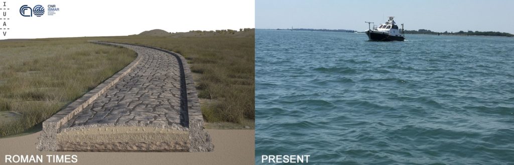
A rendering of the Roman Road (left) in the Treporti Channel of the Venice Lagoon, made on the basis of the multibeam data, and the same area now submerged Credit: Antonio Calandriello and Giuseppe D’Acunto (rendering), and Fantina Madricardo (photo)
The remains of a Roman road may lie hidden beneath the waters of the Venice lagoon, researchers write in the journal Scientific Reports. The team used sonar technology to reveal the archaeological remains along the seabed of the Treporti Channel, an area to the east of central Venice, and their results could prove that large settlements once existed in the area, centuries earlier than previously thought.
“We believe that what we found is a part of a road that connected the southern and the northern part of the Venice lagoon, connecting Chioggia (the ancient Clodia) to the city of Altinum,” says Fantina Madricardo of the ISMAR-Marine Science Institute in Venice, Italy. The scans identified 12 sections of the road, which stand in alignment for more than 1km along what was probably the ancient seashore. The longest single section is 52.7m in length.
The Venice lagoon’s sea level was much lower in Roman times, leaving more dry land than remains today, and divers have discovered Roman artefacts, including amphorae and objects interpreted as paving stones, on the seabed. Nonetheless, debate has long raged over whether the Romans maintained settlements there, hundreds of years before Venice’s traditional founding in the fifth century.
“Venice was thought to be built in a ‘desert’ place without any previous traces of human presence and the Roman findings on and within the seafloor belonged to buildings in the mainland surrounding the lagoon,” the team write in the research paper. Part of the problem is that scholars regarded the lagoon as “a separate space from the mainland,” the team adds, and only a fraction of the finds and excavations carried out there over recent decades have been published.
High resolution bathymetry of the Treporti Channel. Numbers 1 to 12 indicate the alignment of structures. The letters a to d identify other structures found in the area. The zoom-in pictures show the detail of some of the archaeological structures: sites 3, 8-9 and 10 (bottom-right) and the structure a (top-left) which could possibly be part of a harbour structure. The lower part of the picture represents the bathymetric profile extracted along all identified structures (white dashed line)